In winter, the Mississippi River above Lock & Dam 19 from Keokuk to north of Fort Madison, known as Pool 19, provides some of the best birding for diving ducks available in the state. There are also opportunities for observing gulls, although not of the quality found at the east-central locks and dams at Davenport and Le Claire, IA. In either case, unlike for the state’s many public natural areas, reference to the normally indispensable Iowa Sportsman’s Atlas is not much help for a day of scoping the river along Pool 19. The best viewing areas are often obscure and not connected with typical public sites. Some are literally no more than wide spots in a county road, others may be the dead-ends of small-town streets. Descriptions of the birding possibilities in each section of the tour generally assume ideal conditions on the river, the best balance between ice and open water that concentrates the ducks and gulls in particular areas. Naturally this will vary considerably over the course of the Mississippi River’s winter season for any given spot.
Planning Your Outing
The tour as laid out here begins at Fort Madison, IA, moves downriver on the Illinois side to Keokuk, IA and returns upriver on the Iowa side to a few miles north beyond Fort Madison. It is actually doubtful that you could thoroughly bird every point discussed in this essay in asingle,shortened winter day. If you are primarily out for a good session of scoping diving ducks, you will probably want to target the Nauvoo area in Illinois. The angle of the sun will be favorable at any of the several viewing spots in and around Nauvoo during the morning, and if you are not planning to make a full day of it on Pool 19, you are almost certain to get more birds here than at anyother point on the river. If conditions are right, it is not unusual for the diving ducks at this annual staging area to number 10,000–12,000, and even substantially more, in a nearly continuous raft several miles in length. Further, the nature of this section of the Mississippi River is such that when the river is half frozen, which is ideal, the open water tends to be toward the Illinois side. As a bonus, if you are scrupulous about your state list, note that according to U.S. Geological Survey topographic maps, Iowa takes up two-thirds of the river at this point, and most of yourfinds from Nauvoo technically will be Iowa birds, given that diving ducks tend to stay out from shore.
As you might imagine, the most obvious place for sorting through gull populations is at Lock & Dam 19 in Keokuk. This is actually best done from the Ira Smith Boat Access on the Illinois side. There are also ducks to be scoped in the pool above the dam, strictly from the Iowa side, but you'll need to try several spots described in the article to catch everything. Elsewhere, the ice at Montrose, IA, typically offers some roosting gulls to work with as well.
Of course, you can jump to whatever part of the tour suits your fancy, although in some cases you will have to figure out your directions working in reverse. Because this article lays out a one-way circular route, occasionally we have included directions for arriving at a general area while traveling in the opposite direction to the described tour. Some birders, for example, like to do Nauvoo and then go back through Fort Madison and down to Montrose to zero in on birds that have caught their eye from across the way in Illinois. If you are doing a shorter day of it and staying north of Keokuk, you still might want to finish up at the Colusa Elevator in Green Bay Twp., on the Iowa side and just north of Fort Madison, so be sure and note the last section of this essay.
Pool 19 at Fort Madison, Iowa
Riverview Park
Begin the tour at the upriver end of Fort Madison in Lee County (Figure 1). Fort Madison is generally oriented toward the south, from a birder’s point of view, and so in regard to the angle of the sun it is probably best to work from here first thing in the morning. The most extensive area to openly scope the Mississippi River at Fort Madison is Riverview Park (Figure 1.1), and under the right conditions there can be healthy numbers of ducks to sort through from there. The park is readily visible alongside U.S. 61/Iowa Hwy. 2 in town, located between the Iowa-Illinois bridge upriver and 12th St. downriver. At Riverview Park you can scope along the waterfront from near the bridge to downriver at the historic timber fort from which the city gets its name. Enter the park at 6th St. and the standard parking area is easily found. To start off closest to the bridge, which might be your best bet on a sunny morning, drive straight down to the river on the 6th St. entrance road and turn left at Marina Dr., which runs directly along the shore. Head toward the bridge and park in the very large marina parking lot. While on the riverfront, scopedownriver for a shoal that often has good gull populations on or about it, depending on the level of the river. The shoal is closer to the Illinois side, and the best chance at closer viewing is from outside Niota, IL, described below.
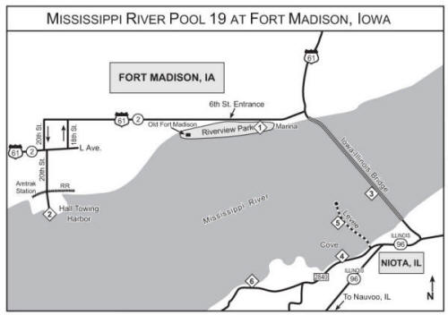
Figure 1. Fort Madison, Iowa: (1) Riverview Park, (2) Hall Towing Harbor, (3) river view from Illinois side at base of Iowa-Illinois Bridge, (4) cove on County Rd. 2840, (5) levee, (6) viewing from County Rd. 2840.
Also while working from Riverview Park, take note of a long, thin, wooded finger of land — an old levee, actually — extending out from the Illinois side, to the right of an inlet at the base of the bridge. You should be able to see a viewing platform standing at the tip of this peninsula. Directions for scoping from this levee and the platform are found below, in the Niota, IL, section.
Hall Towing Harbor
If from Riverview Park it looks like there are good duck populations to examine farther downriver, you can look from Hall Towing Harbor (Figure 1.2). Continue downriver through Fort Madison, following U.S. 61/Hwy. 2. At 20th St., a one-way street, U.S. 61/Hwy. 2 turns south. Take this left-hand turn and proceed down 20th St., still following the highways, three blocks to L Ave., where there is a traffic light. At L Ave., U.S. 61/Hwy. 2 resumes going west, to the right, but you will continue south on 20th, which involves a slight jog to the left. Just before reaching the river going down 20th St., you will cross two adjacent sets of railroad tracks and enter an open, unnamed, commercial-looking space. Hall Towing is seen off to the left, and therefore the area is sometimes referred to in Fort Madison as Hall Towing Harbor. This is an unrestricted space and a long-established spot from which to scope the river. There are usually both duck and gull populations to be seen, with the gulls mainly at a shallow cove to your right, although the shoal mentioned in the Riverview Park section is also visible from here. Fort Madison is not a hotbed for gulls, but Glaucous and Thayer’s have been identified here. Good duck populations may also be visible farther downriver from Hall Towing Harbor. You will be facing generally southwest for these, and therefore the winter sun, riding lower this time of year, might be a problem by mid-afternoon.
To return upriver through Fort Madison, you will turn right at L Ave., and follow the U.S. 61/Hwy. 2 signs. The highways jog north at 18th St., a one-way street.
If you are precise about state listing, according to the Geological Survey maps the Iowa-Illinois border at Fort Madison gives only about one-third of the river to Iowa birds at Riverview Park, and about half the river at Hall Towing Harbor.
Iowa-Illinois Bridge at Fort Madison
If a view from the bridge would seem to help you identify a bird more surely, mainly in the Iowa half of the river, there is a safe and legal spot for scoping just past the Illinois end of the bridge proper. Have a dollar handy for the toll going across, and also be wary while negotiating the somewhat confusing intersection from which you enter the bridge off U.S. 61/Hwy. 2. At the base of the bridge on the Illinois side, meaning after the guard rails end, there is a gravel turn-out offering a nicely open view out over the river (Figure 1.3). Your picture of the river on its Illinois half is cut off, however, by the wooded levee extending out into the river, as seen from Riverview Park in Fort Madison.
Pool 19 at Niota, Illinois
The Niota area is not ideal for general birding of the Mississippi River. Instead, the places described below offer some potential for getting a better look at a given bird or population that you may have spotted from Fort Madison, including looks at the downriver shoal with the gull population. If you feel that you have already seen what there is to see in this section of the river, you can save some time by simply moving on to Nauvoo via Illinois Hwy. 96, as described later in the essay.
Illinois County Road 2840
Otherwise, continue from the gravel turn-out on the bridge to the T-intersection with Illinois Hwy. 96 (Figure 1). Turn right, downriver, through the little town of Niota, and quickly come to where Hwy. 96 curves sharply left, indicated by the standard yellow highway sign with a bold black arrow. Drive straight ahead here, passing left of the yellow arrow sign, onto the gravel road in front of you, Co. Rd. 2840. Very soon you will pass the levy seen from Riverview Park and come to a large cove on your right (Figure 1.4). This spot affords an open if somewhat distant view of the river. Your view is limited to an extent both by the peninsulas on either side as well as by a vegetation-covered islet a short way out, although this stretch of road will allow you to maneuver your position a little to work around the islet. The cove itself, however, often has good roosting gull populations, as well as dabbling ducks. These are all Illinois birds, of course.
The Levee and Its Viewing Platform
If you would like a different angle on any birds in the cove, as well as some alternative views out onto the river, you can walk up the long wooded levee on the right side of the cove. A rough entrance lane is found at the base of the levee. The two-rut lane extends all the way to the end and makes for about a ten-minute walk in snowless conditions. Although the lane is passable all the way in, driving it is not a good idea; you will almost certainly have to back out the entire length, and it will not be plowed if there is snow. Park along the county road however you can manage it, and enter on foot.
You can pick your scoping spots from among the trees along the way, or you can try the viewing platform at the very end of the walk (Figure 1.5). The platform is roomy and solid, and will comfortably accommodate two birders with scopes, but no more. There are no railings on this platform, however, and the short gap between it and the ground of the levee is bridged by taking a step or two across a heavy plank. It also has a slightly homemade look to it in comparison with what you might find at, for example, a state park. In addition to these factors, which alone may give you pause, consider that this platform stands unprotected in whatever winter winds are blowing along the river; not only might there be snow on the platform, but ice as well. Make use of it only under the safest possible weather conditions.
That said, the platform does offer the best view that you are likely to have of the gulls on the shoal, and a unique viewing experience of the river in general.
Farther along the County Road
There is another possibility for viewing of the river and the gull shoal a short distance downriver from the peninsula and the cove. Continue on the gravel county road, soon passing a couple of houses on either side of another gravel road going off to the left. (There is no sign here.) Still following along the river, you will enter a more wooded section of the road, with an isolated homestead appearing on the shoreline side. Drive along here looking for the best openings you can find through the trees to scope (Figure 1.6). There is enough semblance of a shoulder to pull at least partly off the road, and there is very little traffic here. When the road begins to rise and curve left, away from the river, there is no more scoping to be had from it.
Pool 19 at Nauvoo, Illinois
Return now to Illinois Hwy. 96 and turn right, downriver. As the prominent sign tells you, it is nine miles to Nauvoo.
Old Ferry Boat Landing at Parley Street
Entering Nauvoo (Figure 2) on Hwy. 96, you will find yourself on Mulholland St. going west through town. At the end of the shops and restaurants section, look for the famous Mormon Temple on your right, which is impossible to miss, and continue straight west through here on Mulholland, despite that Hwy. 96 now turns south. (Follow the sign for the Visitor’s Center.) At this point you are entering the Mormon historical district of Nauvoo, and Mulholland is now a narrow, one-way lane. Continue west along Mulholland past Partridge St. to a T-intersection with Main St., and turn left (away from the Visitor’s Center). The third street you come to along Main St. is Parley Street. Turn right on Parley and follow it to the old ferry boat landing on the river, simply an open point on the bank (Figure 2.1). Note that Montrose, Iowa, is directly across the river. If conditions are right, here you will have your first look at the mammoth duck rafts that stage from this part of the Mississippi River. Greater Scaup is annual among these rafts, usually a dozen birds or so, but sometimes substantially more. Long-tailed Duck is a good bet, too, and any of the three scoter species may be seen from time to time. Redhead and Ruddy Duck, hard to find in winter away from the river, are regular, the latter ranging unpredictably in number from a few dozen birds to upwards of 2,000 or more.
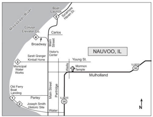
Figure 2. Nauvoo, Illinois: (1) Old Ferry Boat Landing, (2) viewing site northwest of Joseph Smith Historic Site, (3) Municipal Water Works, (4) Nauvoo Colusa Elevator, (5) boat launch.
When finished at the landing, which is at the western extreme of the large point on which Nauvoo sits, continue around the sharp bend heading downriver. The first few hundred yards of this road, to shortly before the Joseph Smith Historic Site, follows closely along the shore and offers unobstructed river viewing, including downriver toward the southeast (Figure 2.2). Parking is easy along the gravel.
Nauvoo Municipal Water Works
Soon you will emerge from this shoreline road back onto Main Street. Turn left and proceed upriver (north) on Main St. to Young St., the first street after Mulholland. Turn left at the sign for the Sarah Granger Kimball Home and follow Young St. west toward the river, past the lane to the Kimball home. When the road curves left, continue straight ahead, past the directional sign for the Maintenance Shop, to the parking lot of the municipal water works, a brick building on the river (Figure 2.3). The supervisor asks that you park on the right-hand side of the lot. From here, walk around the right side of the building to scope the river.
Colusa Elevator Company
There is a commercial grain elevator at Nauvoo with an excellent, roomy spot for open viewing of the river (Figure 2.4). However, visits are only allowed during business hours, Monday through Friday from 8:00 to 4:30; otherwise the entrance gate is closed and locked. The management will allow you to bird there on the weekend if you call a day or two in advance for permission at (217) 453-2216. You can then simply walk around the gate. Even if arriving during business hours, it is best to stop at the office and let them know what you are up to. The office is close to the river and to your left, set back a little from the road.
To get to the grain elevator, return to Main St. from the water works and continue upriver past the Visitor’s Center on your right. Follow the leftward bend in Main St., becoming Broadway, to the elevator’s entrance road. There is ample room to park at the river on the right-hand side of the road.
Public Boat Access and Sycamore Haven Drive
As described above for reaching the Colusa Elevator, Main St. bends riverward at the north edge of town. To reach the public boat access, continue straight upriver here rather than following the bend onto Broadway. At this point you are on Sycamore Haven Drive. Pass Carlos St. on your right and continue through two sharp turns until you come to the boat launch on your left (Figure 2.5), which provides another session of wide-open scoping. From the boat launch, continue north on Sycamore Haven Dr. and look for comfortable places to park alongside the road, of which there are a few here and there (more difficult with solid snow cover), to continue scoping. Vehicles are occasional, but it is not a busy road. You can continue scoping for a little more than a mile after the boat launch, until you begin to see cottages on the river side of the road. If you keep driving along the cottages, eventually one more open spot appears as well, shortly before the turnoff on Co. Rd. 2570. At this point you are viewing waterfowl that are across from the Heron Bend area in Iowa (described later in this article).
To return to Hwy. 96, continue a short distance until you see a road going right, which is Co. Rd. 2570. (Sycamore Haven dead-ends soon after this.) Turn right, going uphill — somewhat bumpy at first — and continue one mile eastward until meeting Co. Rd. 800, which actually means just following the natural curve to the right of the road you are already on. Follow Co. Rd. 800 for 1.5 miles back to Hwy. 96, emerging just northeast of Nauvoo.
Scoping the River While Traveling South to Lock & Dam 19 at Keokuk, Iowa
To continue on to Keokuk from Nauvoo (Figure 3), simply stay on Illinois Hwy. 96. South of Nauvoo the highway runs very close to the river the entire distance to Hamilton, IL, which is across the bridge from Keokuk. There are plenty of scenic turn-outs and picnic areas along the way where you can scope the river if something looks interesting, and it is not unusual for the large staging duck rafts to extend south of Nauvoo. Gulls on the frozen river are always a possibility, too.
Lock & Dam and Pool 19 in Keokuk, Iowa
Lock & Dam 19 (Figure 3) always supports a substantial gull population, both fishing the spillway and roosting about the dam and pool area. However, the gulls below the dam can be quite difficult to work from the Iowa side. The best viewing in this case is from the Ira Smith Boat Access on the Illinois side, described later below.
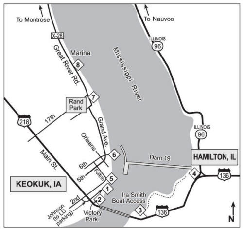
Figure 3. Lock & Dam 19, Keokuk, Iowa, and Hamilton, Illinois: (1) Lock & Dam 19 parking lot, (2) Victory Park, (3) Ira Smith Boat Access, (4) intersection of U.S. 136 and Illinois Hwy. 96, (5) viewing point from 2nd Street, (6) viewing point from end of 6th Street, (7) viewing point at chain-link fence along Grand Avenue, (8) turn-out on Great River Road/Co. Rd. X-28 south of marina.
Important Note: Directions and notes involving Lock & Dam 19 at Keokuk assume that the regular level of public access is available. Depending on circumstances, such access may be decreased during this era of high national security concerns. You should also bear in mind how you might be perceived if pointing a spotting scope at a dam during higher alert statuses, perhaps particularly from the more unofficial locations described in this essay.
Public Parking Area for Lock & Dam 19
The first thing to know is that the public parking area for Lock & Dam 19 does not open until 8:00a.m. If you are starting out in Keokuk, though, you can occupy yourself at some of the other sites discussed below.
If you are entering Keokuk from Illinois, the first cross street you arrive at over the bridge is 2nd St., with a traffic light. If coming into town down Main St. from U.S. 218 in Iowa, 2nd St. is the light before entering the bridge to Illinois. (This bridge is not a toll bridge, by the way.) Turn downriver at 2nd St. and take the first left, heading riverward, at Johnson Street. You will soon pass a church on your left, and Johnson St. will curve leftward. Continue straight ahead, now traveling upriver toward the lock and dam, and pass the Keokuk Waterworks on your left, which has a bold blue sign on the building. Soon this road takes a sharp right turn over the railroad tracks and you will see the sign in front of you that directs you left to the lock and dam parking area. Note the elevated observation deck on your right as you approach the parking lot (Figure 3.1).
The observation deck allows viewing of the top half of the dam, although at something of a distance. The lower half of the dam and the spillway below are obscured by opaque fencing along the spillway wall. Further, the dam’s power plant is attached at a right angle to the dam itself, on the Iowa side, and extends downriver along the spillway, obstructing all of your view of the near end of the dam. In all, following the flight of a single interesting gull working the spillway might be frequently interrupted from here.
Setting up in front of the chain link fence from the sidewalk off the parking lot, you can scope upriver, up the lock, for waterfowl on the pool. Here, too, however, the situation is not perfect. A long, low seawall extends upriver from the power plant into the pool, defining the approach area for the lock. From this angle the power plant blocks all of your view of the water immediately above the dam, and the seawall hides part of the water as well, although you can scope the farther portion beyond it. On the plus side, the seawall is a very popular roost for the gulls, and all in all, one can still make plenty of duck identifications from the parking area, particularly looking straight up the lock.
Victory Park
If gull viewing from the observation deck proves unsatisfying, you may wish to look from Victory Park (Figure 3.2), a small park directly alongside the downriver end of the lock. Its parking area is back down the lane past the Keokuk Waterworks and to your left, underneath the bridge. Victory Park comes with its own frustrations, however. The swing section of the old railroad bridge is now permanently locked in the open position, and so it runs parallel to and slightly elevated above the lock on its farther side. As a result, the swing bridge creates a major block to viewing the upper half of the dam from Victory Park. Because gulls have a habit of changing position vertically as well as horizontally while working a dam, it is debatable whether you will get any extra help here for a particular bird you have your eye on.
If you have spotted a gull from either the observation deck or Victory Park that seems worth pursuing, you can get closer to it from the Ira Smith Boat Access area across the bridge in Hamilton, IL, discussed next. Following the Hamilton section, we will return to Keokuk and its views down onto Lock & Dam 19 and its pool from the city’s bluff-top neighborhoods.
Lock & Dam 19 from Hamilton, Illinois
Ira Smith Boat Access
The Ira Smith Boat Access area (Figure 3.3) across the river from Keokuk offers a chance to work with Lock & Dam 19’s gulls from the closest range in the vicinity. Laughing Gull was identified below the dam in August 2004 and an adult Black-legged Kittiwake a few months later in December. Other rarities at Lock & Dam 19 have included Mew, Great Black-backed, and Iceland Gulls, and even a jaeger species. Thayer’s Gull is annual, and Glaucous and Lesser Black-backed Gulls are seen from time to time as well. The Ira Smith Boat Access itself, meaning the actual launch, offers a complete view of the spillway and dam, although, like from so many other area locations, the dam is a little far away. However, you can walk above the shoreline from the boat launch to a point close enough to identify most anything in the air, although birds all the way on the opposite side of the spillway are probably just within the limits for sure identification by scope.
After crossing the river from Keokuk and exiting the bridge in Illinois, U.S. 136 bends leftward and you will quickly see the overhead crossing lights of the railroad tracks. Just beyond the tracks on the left is an open area with the entrance to the Ira Smith Boat Access, which is not well marked. There is no left turn at this point on U.S. 136, however, so you will have to continue ahead and find a way to return in the opposite lane. Once on the road going into the access area, you soon turn right and the boat ramp is where the road opens up into something like a gravel parking lot. From here, a rough road continues along the river toward the dam. Some of the folks who fish here drive a short way in, but the road gradually deteriorates until it becomes impassable and then nonexistent, and parking is haphazard along the way. You can test for yourself how much of it you want to brave in your particular vehicle, but you might be better off to simply park near the boat ramp and walk in. As you walk toward the dam, before too long a nice open viewing spot will reveal itself from which you can work. It is possible to work your way along the shore to very close to the foot of the dam, but the way grows increasingly untamed and challenging as you go.
Intersection of U.S. 136 and Illinois Hwy. 96
If, while viewing from the Iowa side (or from Ira Smith, for that matter), you are convinced you have something on the order of a Kelp Gull cruising the dam all the way east at the Illinois end, there is a way, somewhat on the desperate side, to get a look down onto this end, including part of the pool directly above the dam. U.S. 136 and Illinois Hwy. 96 meet in such a way as to form a large, triangular traffic island a little upriver from the Ira Smith entrance. From the stretch of wide, paved shoulder across from the riverward side of this triangle (Figure 3.4), there is an open view down onto the dam, although width-wise your field of view is fairly limited. Traffic is heavy here, and it is recommended that you find a safe place to park and walk to this point, despite that there is ample room to pull over onto the shoulder in your car.
Lock & Dam and Pool 19 from the Bluffs of Keokuk
There are several public places up in the bluff-top neighborhoods of Keokuk that offer open and complete views down onto Lock & Dam 19 and the pool immediately above the dam. They are distant views, but depending on your equipment and identification skills, they are reasonably practicable for picking out birds.
From the lock and dam parking area, or from Victory Park, return to Johnson Ave., proceed uphill back to 2nd St., and turn right. (If returning to Keokuk from Hamilton, Illinois, simply turn right on 2nd St. at the end of the bridge.) Follow 2nd St. past the Illinois bridge and uphill into the residential neighborhoods, to the crest at High Street. Continue downhill, and just past Morgan St. the road bends left at a point where there is open viewing down onto the dam (Figure 3.5), giving a complete look including the spillway waters. There is just enough room for one car to park along a wide spot here, but if this does not feel comfortable, simply follow the bend up to the next intersection, park along one of the streets, and walk back down.
The bend here is the transition of 2nd St. into Fulton Street. When finished, continue on up Fulton, away from the river, to 5th Street. Turn right on 5th and soon come to a four-way stop, Orleans Avenue. Proceed on the street that goes ahead diagonally and leftward, Grand Ave., rather than making any right-angle turn onto Orleans. Once on Grand Ave., take the first right, 6th St., to its end (a very short section of street) (Figure 3.6). Here there is a sweeping, elevated view of the pool directly above the dam, in all its parts. Be assured that this is a public area, despite the somewhat private feel to this narrow spur between two homes.
To scope from still farther upriver in Keokuk, continue on Grand Ave. past 14th St. until you come to a stop sign, with a picturesque neighborhood park in front of you, Rand Park. Continue straight through to the park’s entrance lane, which immediately curves toward the river. Stay to the right when you come to a fork, heading instead for the 90-degree left turn in the corner of the park, called “J. A. Finerty Drive.” Park along J. A. Finerty Dr. and cross the actual city street just below, Grand Ave., which has no parking, to the strip of grass before the chain-link fence (Figure 3.7). There is plenty of room to set up along this strip for scoping down over the river, and the low chain-link fence does not impede your view despite how it first appears from where you parked. Again, this strip is intended for public river viewing, as the park benches will attest.
The Great River Road Just Outside of Keokuk
Shortly upriver from Rand Park there is a turn-out along the Great River Road that has produced some excellent duck species on the river in recent years, including Greater Scaup, Long-tailed Duck, and both White-winged and Black Scoters. Continue along J. A. Finerty Dr. and exit Rand Park on its upriver side onto 17th St., and turn right. (If you wish to return to U.S. 218, turn left on 17th and follow it seven blocks beyond the park back to Main Street.) Quickly come to a stop sign and turn left onto the Great River Road, which is also Co. Rd. X-28. Shortly along the river, just before a marina, find the modest gravel turn-out from which to scope (Figure 3.8). There is another such turn-out a little more than a mile past the marina. Both offer open viewing of the river.
Pool 19 at Montrose, Iowa
In Montrose (Figure 4) you will be working with the same duck populations as described for Nauvoo, but from the opposite side of the river. The nature of the river between the two towns seems to be such that most of the Iowa side freezes before the Illinois side. (An exception is noted in the first section below.) Consequently, while the duck rafts may be closer to the Illinois shore, any gulls on the ice are better viewed from the Montrose area, and recently a roosting Iceland Gull was identified from this neighborhood. If it is late afternoon on a sunny day, of course, Montrose will offer a better light angle on the ducks, distant or not, than Nauvoo. At the end of the general Montrose section, there are directions for finding your way to the starting point if arriving from Fort Madison.
Co. Rd. X-28/Great River Road, Just Downriver Outside of Montrose
Continue along the X-28/Great River Road about five miles into Montrose. As you near the town, you will enter a section of wooded bluff (Figures 4.1 and 5.1). If the river is especially frozen, there often is still open water with a concentrated duck population down below this bluff and close to the Iowa side (and this population may be present even when there is other open water). Parking is not easy along the almost nonexistent shoulder here, but on the other hand, there are only occasional vehicles. Scoping is through the bare trees —not exactly ideal, but Greater Scaup, White-winged Scoter, and Long-tailed Duck have been identified from this point.
Waterfront in Downtown Montrose
Fortunately there is more wide-open scoping in Montrose itself. Continue along X-28 and soon the road leaves the woods and drops down into the residential neighborhoods of town. Follow along the natural turns in the road even as the street names change. At the stop sign at Middle Rd., turn right, as indicated by the green Great River Road sign, and continue. When you find yourself facing the grain elevator, continue along the leftward bend. There will be one more rightward bend and then before long you come to a stop sign at Main Street. Turn right and follow Main St. over the railroad tracks down to the river to a small, unnamed waterfront park (Figures 4.2 and 5.2). Across the river you will see Nauvoo and its Mormon Temple on a rise. Scan out over the river for duck rafts, which, although perhaps closer to Nauvoo, are still identifiable (sometimes just so). Also look for roosting gulls on the ice, usually upriver. Directions for closer scoping of any such gulls will follow next. Meanwhile, move over to the upriver end of the present parking area and look past the floating restaurant, from its left, for gulls gathered on the ice near shore.
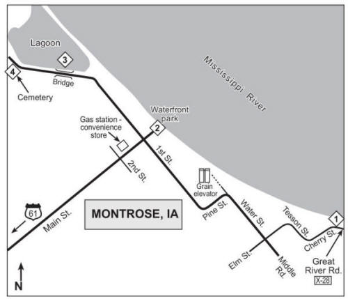
Figure 4. Montrose, Iowa: (1) wooded bluff-side viewing on Great River Road/Co. Rd. X-28, (2) waterfront park in Montrose, (3) lagoon, (4) Montrose Cemetery.
Points Upriver Outside of Montrose
From the park, turn right on 1st St., the first cross street up from the river. Shortly along the way on 1st St. you will pass a lagoon (Figure 4.3) on your right and Montrose Cemetery (Figure 4.4) on your left. In winter the cemetery seems to be one of those unlikely spots that consistently produces an interesting bird or two. For example, there is a creek bordering the cemetery to your left as you enter, and Winter Wrens (and even a mid-winter Marsh Wren) have been found here. The cemetery has hosted Eurasian Tree Sparrow as well. The lagoon across from the entrance is also worth checking for dabbling ducks.
The entrance lane to Linger-Longer Rest Area (Figure 5.3) is on the right side of 1st St./Great River Road just before it meets U.S. 61, one-half mile from Montrose Cemetery. It offers a slightly elevated spot for river scoping, primarily for gulls on the ice, including what you may have seen close to shore from the waterfront park. There is a plaque here, by the way, commemorating the point where the Mormons crossed the river from Nauvoo to begin their famous trek to Utah, including a curious story involving “quail.” Perhaps more importantly, there is a reliably open restroom as well.
If there are birds still farther upriver you would like to check, enter onto U.S. 61 and go north one-half mile to 280th St., the first right-hand road, at the gas station/convenience store. Follow this road a short way to the river, and where it turns sharply left, park on the short section of abandoned roadway to your right (Figure 5.4). There is easy scoping from this elevated point, and you can walk along the very wide shoulder a bit to adjust your view. Although it looks promising, however, there are no further viewing points upriver along this road.
Starting in Montrose if Arriving from Fort Madison
The turn-off from U.S. 61 onto Great River Rd., which will take you into Montrose, is at the Linger-Longer Rest Area (Figure 5.3). Linger-Longer is approximately five miles down from the sharp, southward turn of U.S. 61 just outside of Fort Madison; it is found where U.S. 61 bends rightward. Follow the Great River Rd. one mile to the stop sign at Main Street. (You are now on 1st Street.) At this point you can turn left, to the waterfront park (Figure 5.2) described above, or continue on to the bluff-side viewing along Co. Rd. X-28 (Figure 5.1), also described above. For the latter, proceed several blocks downriver on 1st St. and then follow the natural curve of the road leftward, where it becomes Pine Street. At Water St., with the grain elevator on your left, turn right. Upon reaching Elm St. after this, turn left following the Great River Rd., and continue following the curves until you leave town and move uphill into the wooded bluffs along the river.
Pool 19 at Heron Bend IN IOWA
One and a half miles upriver along U.S. 61 from 280th St. as described above, after mile marker 13, is the entrance to Heron Bend in IA, a Lee County natural area on the river. Alternately, if coming from Fort Madison, Heron Bend is after mile marker 12, about 2.5 miles from the sharp southward turn that U.S. 61 takes just outside of town. Look for a brown wooden sign along Heron Bend’s entrance lane reading “Lee County Conservation Board.” Follow the gravel lane past this sign and around a leftward turn. Just after passing the conservation board office on your left, take the right-hand turn on the gravel lane, and proceed to its end at the river. At that point on the Mississippi River you are across from the farthest viewing point along Sycamore Haven Dr. outside of Nauvoo.
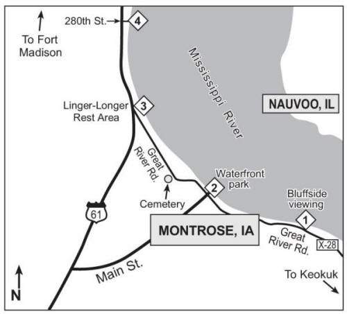
Figure 5. Expanded map of Montrose, Iowa area: (1) wooded bluff-side viewing on Great River Road/Co. Rd. X-28, (2) waterfront park in Montrose, (3) Linger-Longer Rest Area, (4) abandoned roadway on 280th Street along Mississippi River.
Fort Madison, if Arriving from the South
Perhaps you skipped Fort Madison at the beginning of your outing, or you have started the day at Keokuk. To begin at Hall Towing Harbor (Figure 1.2) (see Fort Madison section at beginning of essay), enter town from Heron Bend along U.S. 61 (which is joined by Iowa Hwy. 2) and proceed to 20th St., which has a traffic light. The numbered streets are in descending order as you come in from the west, and you will pass a cemetery on your right just before 20th. Turn right and follow 20th St. to its end at the water.
Pool 19 at Green Bay Township, Iowa (“Colusa Elevator” in Iowa)
For one last bit of scoping Pool 19 at the end of the day, there is a fairly obscure section of river a little north of Fort Madison, IA and a few miles east off U.S. 61 that consistently has a small population of diving ducks, recently including Greater Scaup and Long-tailed Duck, when much of the rest of Pool 19 is frozen. Follow U.S. 61 about four miles north from the Illinois bridge in Fort Madison to J-50/190th St. on your right, north after mile marker 27. Proceed east toward the river on J-50 about five miles until it ends at X-50/Green Bay Rd. (After the first two miles, J-50’s pavement becomes gravel.) Turn right on Green Bay Rd. where you will see a “Dead End” sign. Two miles down this stretch of paved road is the Green Bay boat access, just after the road bends right, and beyond that another of the Colusa Elevator Company’s grain elevators. The boat access is worth a look for open water, but usually it is found beyond the elevator. Green Bay Rd. closely hugs the river after the access, and you can easily pull alongside the gravel for scoping. As you look for ducks, you can drive a short distance past the turnoff to the Colusa Elevator Co. Annex (there is a sign), but soon after that the road ends at the private driveway of the house you see up ahead of you.
If snow conditions are right, the back roads throughout this general area, which is flat, bottomland row crop territory, can be very good for longspurs and sometimes Snow Buntings. Eurasian Tree Sparrows have been found in the area of Green Bay Access and the elevator.
Should you want to return to Hwy. 61 going north rather than south, simply stay on X-50/Green Bay Rd. as you return from the elevator, ignoring J-50/190th St., and after about six miles you will emerge just south of Iowa Hwy. 16 near Wever.
ACKNOWLEDGMENTS
Supplemental information for this article was generously provided by Aaron Brees, Bob Cecil, Chris Edwards, Chuck Fuller, Jim Fuller, and John Rutenbeck.